Tired of crowded peaks? The Chachacomani Bolivia ascent offers an authentic and less frequented adventure in the heart of the Cordillera Real, where every step tells a story of resilience and majesty. This detailed account guides you from the Cruz Pampa valley to the 6074-meter summit, passing through base and high camps, revealing key stages and technical challenges. Discover how to overcome crevasses, steep slopes up to 45 degrees, and enjoy breathtaking panoramic views of Lake Titicaca and the Cordillera Real.
- Chachacomani: an accessible 6000-meter peak in the Cordillera Real
- The approach from the Cruz Pampa valley: between bofedales and high-altitude landscapes
- The ascent to high camp: final acclimatization on the glacier
- Summit day: 800 meters of elevation gain on Chachacomani’s glaciers
- Preparation, descent, and final notes for the expedition
Chachacomani: an accessible 6000-meter peak in the Cordillera Real
A little-known giant in Bolivia
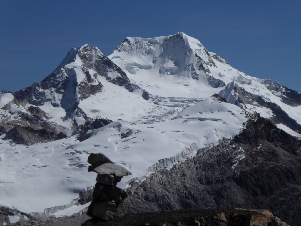
The Chachacomani (6074m) in the Bolivian Cordillera Real is not frequently visited. Located near Lake Titicaca, it offers spectacular views. First ascended in 1947 by Dr. Federico Fritz. Unlike Illimani or Ancohuma, this wild route avoids the crowds, offering an authentic experience for experienced mountaineers.
More of a physical challenge than a technical one
Rated PD/III, the ascent is primarily physical due to the altitude. Starting from Cruz Pampa (4480m): 3h to Base Camp (4470m), then 3h30 to High Camp (5100-5130m) on the glacier. On summit day, 6h of climbing (800m elevation gain) on 45° slopes, crossing crevasses and a glacial ridge. Return to Base Camp, then descent to La Paz the next day.
Essential gear: crampons, Gore-Tex jacket, glacier glasses. Acclimatization in La Paz is crucial via “climb high, sleep low.” Only a few expeditions succeed each year. Poor acclimatization significantly increases the risk of altitude sickness.
The approach from the Cruz Pampa valley: between bofedales and high-altitude landscapes
The starting point: Alto Cruz Pampa (4450m)
The trek begins at Alto Cruz Pampa (4450m). After a 3-hour drive from La Paz, this village becomes the starting point. Muleteers load equipment (tents, ropes, food) onto donkeys. The rarefied air immediately activates acclimatization. The arid landscapes and snow-capped peaks of the Cordillera Real announce the challenges of the ascent. A panoramic view of the glaciers mentally prepares mountaineers. Final technical checks are carried out before entering the valley.
Crossing the bofedales, a unique Andean ecosystem
The first stage crosses the bofedales, Andean ecosystems characterized by wet moss and peat bogs. The spongy terrain requires careful walking to avoid getting bogged down. Endemic vegetation, such as Distichia muscoides, regulates water and supports biodiversity. These wetlands store glacier meltwater, essential during the dry season. Their greenery attracts Andean geese and vicuñas, adding a wild dimension to the expedition.
Arrival at base camp (4470m)
After a 3-hour walk, base camp is set up at 4470m. This site includes a kitchen tent and flat camping areas, ideal for initial acclimatization. A nearby stream provides a source of drinking water. The night spent here is crucial for adapting before the glacier climb. Sub-zero night temperatures emphasize the importance of suitable technical gear, physically preparing mountaineers for the next stages.
- Departure: Alto Cruz Pampa (4450m)
- Terrain: bofedales (wetlands)
- Duration: 3h
- Arrival: Base Camp (4470m)
The ascent to high camp: final acclimatization on the glacier
Progression towards the pass and the start of the glacier
From base camp at 4470m, the progression northwest crosses a lush valley. After about 1 km, a stream winds at 4700m. The trail becomes steep and rocky. Crossing the pass before the glacier requires particular attention. A demanding climb with unstable rocks and changing weather.
Setting up high camp at 5130 meters
High camp (5130m) is crucial for acclimatization. Mountaineers rest and hydrate before the final assault. Poor preparation compromises the summit ascent (6074m). High altitude requires rigorous oxygen and time management. The camp offers strategic refuge before the final effort. Freezing temperatures, suitable equipment necessary.
| Step | Altitude | Estimated Duration | Description |
|---|---|---|---|
| Approach to Base Camp (Departure: Alto Cruz Pampa, Arrival: Base Camp) | 4480m → 4470m | ~3 hours | Walk through the valley and bofedales |
| Ascent to High Camp (Departure: Base Camp, Arrival: High Camp) | 4470m → 5130m | ~3 hours | Progression towards the glacier via a pass |
| Summit Day (Departure: High Camp, Arrival: Summit) | 5130m → 6074m | ~6 hours | Glacial ascent, crevasses, plateaus, and technical 45° ridges |
| Descent (Departure: Summit, Arrival: Base Camp) | 6074m → 4470m | Variable | Return via the same route |
Summit day: 800 meters of elevation gain on Chachacomani’s glaciers
The night departure and the long glacial climb
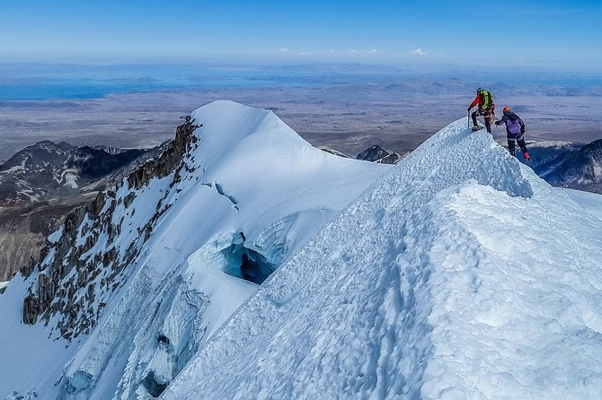
The night departure often begins at 2 AM, under headlamp light. This initial phase crosses the glacier for about 3 hours. Then, a long traverse of glacial plateaus extends for another 3 hours. Physical endurance is essential to overcome this demanding stage. Glacial conditions require constant vigilance.
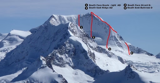
Technical challenges: crevasses and steep slopes
Navigating between the crevasses at the foot of Chachacomani’s ridge requires extreme caution. The east-facing slopes steepen up to 45 degrees, representing the most technical section. Every step must be calculated to ensure safety. The slightest mistake could be fatal.
Ropes and crampons are essential for crossing these unstable areas. A misjudgment can lead to a fatal fall. Prior acclimatization is crucial to maintain energy during this demanding ascent. Guides emphasize the importance of this stage.
Arrival at the 6074-meter summit and the panoramic reward
Reaching the 6074-meter summit offers spectacular panoramic views of the Cordillera Real and Lake Titicaca. This moment of reward justifies all the efforts made. The solitude of the heights reinforces the sense of accomplishment. Mountaineers rarely share this intense experience.
- Positive elevation gain: Approximately 800 meters from high camp.
- Total ascent duration: Approximately 6 hours.
- Main obstacles: Crossing crevasses at the foot of the ridge.
- Final slope: Steep sections up to 45 degrees.
According to certified guides, rigorous acclimatization is essential before the ascent. Suitable technical equipment avoids risks associated with extreme altitudes. The return to base camp then begins cautiously. Safety takes precedence over all other considerations.
Preparation, descent, and final notes for the expedition
The descent and return to civilization
After reaching the summit of Chachacomani (6,074m), the descent begins. Mountaineers descend towards high camp (5,200m), then to base camp (4470m). The route crosses unstable glaciers and crevasses. The next day: return to Alto Cruz Pampa and La Paz. A demanding final phase.
Key tips and historical note
- Prior acclimatization: Several days in La Paz (3,600m) are essential.
- Physical condition: Excellent endurance necessary for walking and climbing.
- Technical equipment: Crampons, ice axe, rope, cold weather protection.
- Logistics: Local agency for mules, certified guides, and safety.
First ascent in 1947.
The Chachacomani, first climbed in 1947 by Dr. Federico Fritz, remains a
FAQ
What is the actual difficulty of the Chachacomani ascent?
The Chachacomani ascent is rated PD/III or AD, indicating moderate technical difficulty but high physical demand due to the altitude. Although the route does not present extremely technical sections, glacier progression, crevasse crossing, and slopes up to 45 degrees require good physical condition and solid prior acclimatization.
Several days of acclimatization in La Paz (3600 meters) are essential to minimize the risks of acute mountain sickness. This allows your body to gradually adapt before the final push to the summit.
What is the classic route to the summit from Cruz Pampa?
The ascent begins at Alto Cruz Pampa (4480m), followed by a 3-hour walk to base camp (4470m) through the bofedales. The next day, progress is made towards high camp (5130m) in 3 hours, then on summit day, a 6-hour ascent crosses the glacier, crevasses, and steep slopes to reach the 6074m summit. The descent usually takes place on the same day to base camp.
Depending on the mountaineers’ level, the descent can be done either directly to base camp on summit day, or in two stages, first passing through high camp before rejoining base camp the next day.
The route passes through unique landscapes, such as the bofedales (Andean wetlands), before approaching the glacier. Each stage is strategic for acclimatization, with well-defined key steps to secure the expedition.
How many days should be dedicated to the Chachacomani ascent?
A full expedition generally lasts 4 days on site. The first day involves reaching base camp from La Paz, the second ascending to high camp, the third reaching the summit and descending, and the fourth returning to La Paz. Summit day itself takes approximately 6 hours of ascent from high camp.
This pace allows for gradual acclimatization and recovery time between stages. A rapid descent after the summit is crucial to avoid complications related to prolonged altitude exposure.
What equipment is essential for climbing Chachacomani?
A complete technical equipment is necessary: crampons, ice axe, helmet, climbing rope, harness, carabiners, and technical clothing adapted to altitude (thermal layer, windbreaker, insulating jacket). Polarized sunglasses and high-protection sunscreen are also essential to protect against intense UV rays in high mountains.
Glacial conditions require equipment adapted to crevasses and steep slopes. Good logistical preparation, often organized with a local agency, guarantees safety and comfort throughout the expedition.
What is the best time to attempt the Chachacomani ascent?
The ideal season extends from May to October, during the dry season in the Andes. These months offer more stable weather conditions, with fewer risks of precipitation and better visibility. Avoid the rainy season (November to April) when trails become slippery and crevasses more dangerous.
This period also coincides with milder temperatures and optimal sunshine to fully enjoy the panoramic views of the Cordillera Real and Lake Titicaca from the summit.